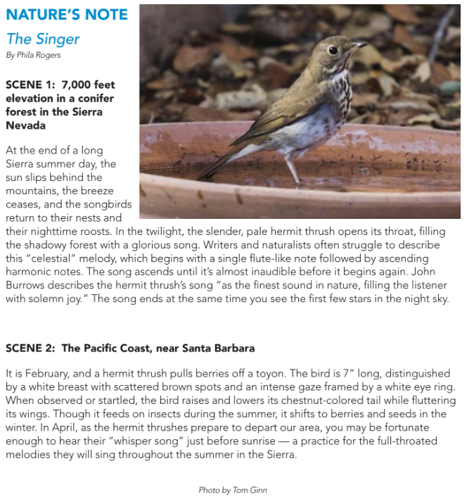

We love our Samarkand campus with its 16 acres of cultivated gardens and trees located on a knoll above Mission Creek with wide views of the mountains.
But there is so much more.
Our one-acre native plant garden captures the floral beauty of coastal California. A fountain made from a sandstone boulder attracts birds to drink and bathe and is a lovely place to sit overlooking the garden with the mountains beyond.
Samarkand is also an arboretum with its 350 trees, many of which are labeled. There is an accompanying Tree Map available in the nature corner in the library. On the self-guided tour, as you linger at each tree, you can imagine the complex system of roots underfoot and the miles of fungal fibers uniting them.
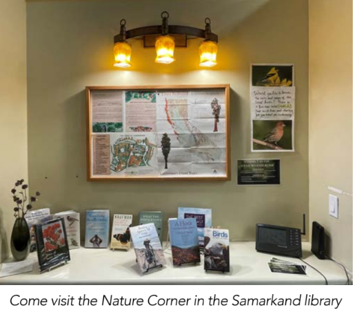
The nature corner in the library features books and field guides on the natural history of our area. You will also find a weather monitor that gives real-time weather specifically for our campus. Our Samarkand weather station is located on the roof of the Mountain Room.
By Ted. R. Anderson
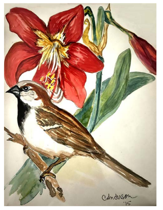 The House Sparrow originally inhabited a broad geographic region stretching across Europe and North Africa and throughout most of Asia except mainland China. It lived in close association with people in both rural and urban communities and is now often referred to as an “obligate commensal” of human beings, meaning that it is dependent on its human neighbors.
When large numbers of people fled Europe in the mid-19th century to live on other continents, many missed their familiar avian neighbors, including the House Sparrow. In the mid-1800s, 100 sparrows were brought to the United States from England aboard the Europa and released in Central Park. With the help of subsequent introductions, the species spread across the continent, making their way to the Pacific coast by 1915. Similar introductions followed in Australia, Argentina and South Africa. Range expansions increased widely from each of these sites so that today the House Sparrow is widely distributed on every continent except Antarctica.
The House Sparrow is not common on the the Samarkand campus, but a lone male does spend much of each day repeatedly chirping near the entrance to our Smith Health Center, hoping, no doubt, to attract a female to his chosen nest site. My favorite place for sparrow-watching, however, is Renaud’s. Carol and I each order one of their fabulous pastries and a cup of coffee and sit in the outdoor patio. There I watch the sparrows hop around under the
tables picking up crumbs that fall to the ground as patrons eat their pastries. Clearly sparrows have good taste!
Ted Anderson is a retired professor of Avian Biology, and the author of “Biology of the Ubiquitous House Sparrow” (Oxford University Press). The watercolor of the house sparrow (above) was painted by Carol Anderson, Ted’s wife.
Phila Rogers is now 96 years old and legally blind. She has decided to occasionaly have some guest columns of which this is one.
It wasn’t that I outgrew my Eastview apartment, with its spacious rooms and expansive views, it outgrew me. With my dimming eyesight, I no longer could see the Mission bell towers and could barely discern the shape of Montecito Peak. From my new apartment at Brandel Hall, I have a pleasant view of trees, south sun, and flocks of musical goldfinches. Instead of woodpeckers visiting my suet, I have overwintering warblers with their more modest appetites.
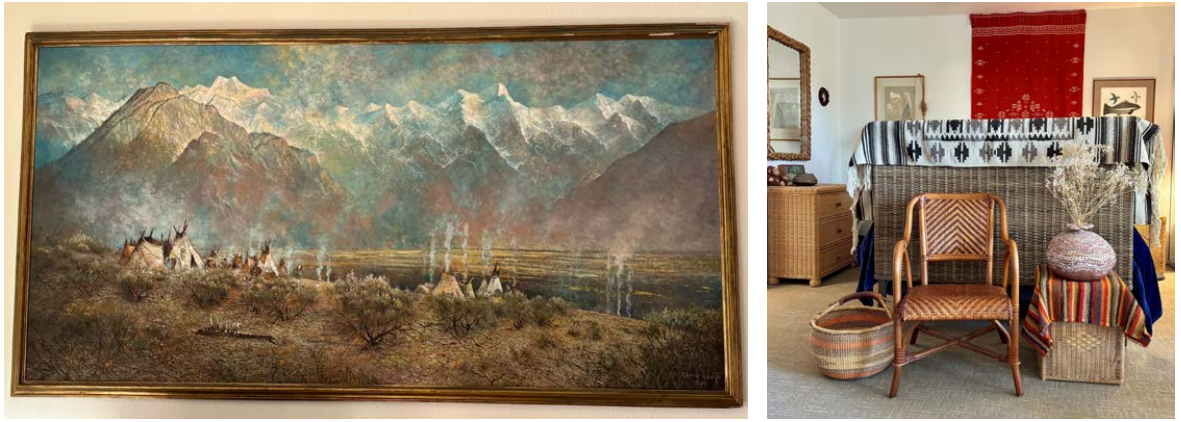
Moving to a studio apartment, gave me a chance to “lighten my load.” I kept my favorite painting of a snowy mountain range with an Indian encampment in the foreground inspiring me to decorate my apartment in a style I call neo-tepee, allowing me to use my collection of hanging rugs, pots and woven baskets.
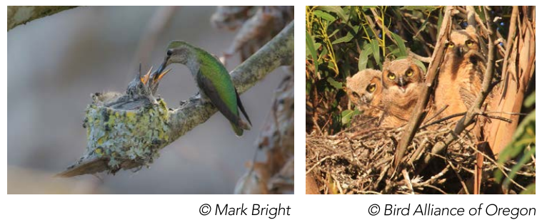
I am not the only January nester. The small Anna Hummingbirds and the large Great Horned Owls also build their nests in January. The hummingbirds fashion their nests from grasses and spiders web decorated with lichens while the owl builds a casual structure from sticks piled up in a tall tree.

Maybe we can’t brag about brilliant splashes of color everywhere like they can back east, since Fall is subtler in California, but there are still clear signs that the seasons are changing. As the days grow shorter, shadows grow longer, giving a rich, baroque look to the landscape. The air achieves a balance between the cool, damp marine flow and the drier air of the mountains. The breeze has a tantalizing sweetness of ripening fruits and crumbling leaves.
In the Native Plant Garden behind Eastview, you’ll see the billowy bushes of the Toyon, whose succulent berries will be red by Christmas. Further down is the sprawling “Roger’s Red,” a subspecies of the California wild grape. The White-crowned Sparrows arrived in October and fill the garden with their sweet songs.
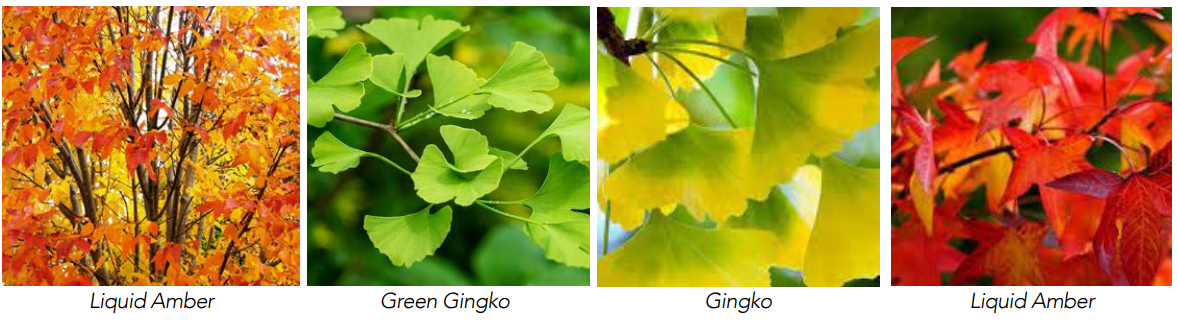
In Oak Park, the leaves on the big sycamores are tawny now. Around town, you’ll see liquid amber trees, with a palette of oranges and maroons, and the ginkgo trees will soon turn a pure brilliant yellow. The lone survivor of an ancient species, these trees shared a landscape with the dinosaurs.
Fall is not just about plants. It’s also about critters—the big Orb Weavers that weave symmetrical webs and then plant themselves in the center waiting for trapped insects. And if you find yourself in the dry country, look for the astonishing sight of tarantulas on the trails in search of mates.

As you approach the entrance to buildings Northview and Westview, your eyes may be drawn to two red rocking chairs on a small patio in back of Sylvia Casberg’s apartment. The patio is surround by a simple wrought iron fence and a gate that is always open. Potted red geraniums hang from the eave and two beautiful wind chimes make music in the lightest breeze. A curving pathway of crunchy white gravel leads to the street. A white pottery birdbath attracts birds and the attention of photographer Tom Ginn. In early summer the garden features a bird of paradise plant surrounded by California Poppies and orange nasturtiums. Later, saucer-sized red- orange hibiscus attracted watercolorist Sue Fridley, whose painting is featured here.
Asking about Sylvia’s early garden experience, she said, “As a child I was encouraged to grow a Victory Garden but only radishes came up which I figured weren’t going to win a war. I had better luck when nurseries began offering small plants. I talked to the plants reminding them that ‘you grow or out you go.’”

If you walk by early in the morning, you may see Sylvia wrapped in a blanket enjoying a cup of coffee. Later in the day it might be a glass of wine sipped as she enjoys the sunset.

Dear Friends:
In order to do justice to Ann Allen’s lovely painting of her birdbaths in Where The Birds Are, I eliminated two photos which helped tell the story.
Interspecies bird feeding is unusual but not rare. The behavior is fueled by the powerful hormones which respond to the lengthening days in the spring.
Birds (male or female) may become a “helper” if their own nest is destroyed or if a bird is unable to find a mate. If nestlings have lost their parents and their calls are loud and persistent enough, a neighboring bird of another species may fill in as a parent.

Nestlings and fledglings learn their songs and calls from the feeding parents. Results can sometimes be disastrous as in the case where the helper, a gull of one species feeds gull of another species and the recipients no longer know when to migrate, I’m assuming our four juncos grew up to be proper adult juncos and didn’t leave for Mexico in the fall.

In December each year, many in the country participate in the annual Audubon Christmas bird count. For the last ten years Samarkand has mustered up a dozen willing souls to walk Samarkand’s 16 acres to record the birds seen or heard. Half of their time was spent in Ann and Bob Allen’s Oak Crest garden, over the fence at the far end of the Native Plant Garden, where many species of birds come to visit their bird baths.
In the spring, local birds build their nests on the beams supporting the roof that overhangs part of their patio. Several years ago, when a pair of Dark-eyed Juncos were feeding their nestlings there, a stranger showed up with food in its beak. The Juncos chased off the intruder and then realized that a helper had shown up. The three birds fed the nestlings until they were old enough to leave the nest.
The stranger was a different species, a Pacific Slope Flycatcher with an upright posture and a slender beak for catching insects – a migrant who spent its winter in Southern Mexico. When the fledglings left the nest, the Flycatcher was out of a job. It called repeatedly for its lost family.
Come celebrate early summer at the Native Plant Garden, where you can enjoy orange poppies, blue and purple verbena, iris and fragrant sage. Stop at the sandstone fountain for wildflowers, birds and grand views.
This is one of the noteworthy days of the year, the fall equinox and the first day of fall. Like the spring equinox six months from now, day and night are roughly equal in length. The Bewick’s Wren is singing a more joyous song and the Oak Titmouse sings a combination of their spring halleluiahs with their raspy call notes. Nothing will come of it, of course, and the days will continue to grow shorter by two minutes a day until we are jolted by darkness falling by 7 PM.
In Santa Barbara on the south coast, a 100 miles west northwest of Los Angeles, fall doesn’t really show up until October, when the California grapevine turns red on the fence and the winter birds show up in the coastal gardens.
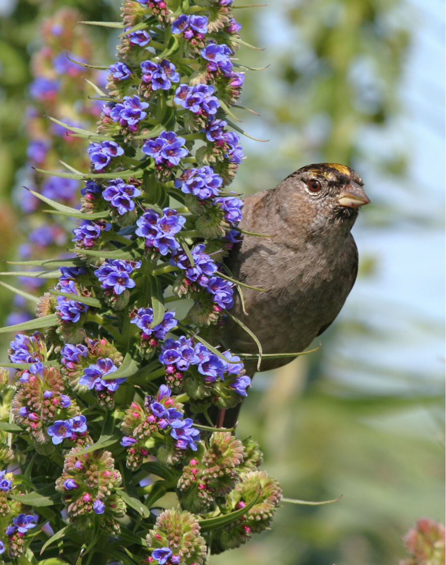
Over the last few days, Bay Area birders are plucking my heart strings by reporting the first Golden-crowned Sparrows of the season. I remember those chilly mornings in the Berkeley Hills when I would walk up the street towards the pasture whistling their song. If they had arrived in the early morning hours after a long night’s flight, they answered me with one or two minor key notes. I would yelp with joy and dance a quick jig. When I returned home, I made an entry in my notebook, circling the date in red.
It would be a few more days before the little flocks worked their way into the neighborhood to settle into their winter territories. I wondered if these birds were the ones that had come last year and maybe several years before. The good news was that they remained until mid or late April, developing the bright yellow crown, before departing for the far north. During the winter you could count on them singing just before it started to rain.
As far as I know there are no golden crowns in this neighborhood or even in Oak Park. They are most often reported in weedy fields in open areas like the upper Elings Park.
A single mature male has spent the summer feeding with several Song Sparrows in a clearing near Los Carneros Lake. Apparently, it declined to join the others of its kind for the migration north in April. Was he damaged in some way or simply lacked the normal instinct, the irresistible urge to migrate?
Hearing the Western Tanagers on the move, I will start listening for our winter birds, though I know it’s probably too early. I arrived at Samarkand as a reluctant migrant from Northern California at this time nine years ago. It was during the lull between the seasons. I was disconsolate. I looked for one familiar bird. Finally, there it was — a California Towhee scratching in the leaves alongside the pathway.
Something did arrive early this year, a substantial rain but with hardly a sprinkle here. Elsewhere, it was enough to signal the annual nuptial flight of the termites when some of these subterranean creatures grow a pair of gossamer wings for a day’s fling above ground in the bright air. The queen ascends high in the sky pursued by ardent males eager to mate with her. Then as quickly as it began, it was all over and the termites resumed their lives in the dark with a pregnant queen, leaving behind a shimmering carpet of discarded wings.

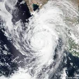
I had assumed this early storm was like the ones to follow, moving down the coast from the north. But the cause was Hurricane Kay, an extensive, well-organized storm which had originated off the coast of Baja California, slowly weakening as it moved north to bring varying amounts of rain.
Nature sent us a consolation prize though — a double rainbow which felt more like a gateway to grander things.

