I lived most of my life in the Berkeley Hills where I looked west through the Golden Gate knowing that it is the only sea level break along the coastal mountains. At night, two lighthouse beacons told me where I was – one flashing light on Alcatraz Island just inside the Gate and the other 25 miles offshore on the Farallon Islands.
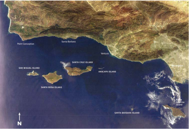
When I first came to Santa Barbara, I looked for what might be special. I admired the mountains at the edge of town which are twice as high as the Berkeley Hills. Then l remembered that in Santa Barbara you looked due south to the ocean because 30 miles west at Point Conception, the coastline turns abruptly 90 degrees east. Near Ventura the coastline straightens up again and resumes its roughly north/south trend of the rest of the California coastline.
On clear days I can see the profiles of Santa Cruz and Santa Rosa Islands which are part of the five Northern Channel Island group, giving Santa Barbara another distinction in a state with few offshore islands.
And how about another fact: it is the motion of the San Andreas fault over time that has twisted the coastal mountains in the region to also run east/west, which is why on the maps they are referred to as the Transverse Ranges.
But aside from all the interesting geology, what I truly love about the mountains behind Santa Barbara is the way they reflect back the low winter sun to help give us the mild winter climate.
