When I got to know fellow Samarkand resident Irene Coker, I learned she had her own Santa Barbara story. Though born in Santa Barbara, she grew up elsewhere, returning when she was 18 years old. But her great-uncles had come to Santa Barbara years before from Italy, working first as gardeners in Mission Canyon and then later as stone masons, constructing walls near the Mission.
It was the talented stone masons from Italy who gave Santa Barbara its distinctive look with their handcrafted buildings, walls and bridges, many made using our local sandstone.
A trip to the Santa Barbara Botanic Garden in Mission Canyon will show you even earlier uses of sandstone. In a climate with a short rainy season, the Mission Fathers realized they would have to store water to see them through the long dry season. You can still see the dam built by the Chumash people in the early 1800s under the supervision of the Mission Fathers. The water was impounded by the dam and later traveled down to the Mission gardens via aqueducts. At the Garden, you can also see one of the immense boulders brought down from the mountains in an earlier debris flow.
I love the sandstone features all over town, I’m glad most of the sandstone remains on the mountain slopes, because when we walk at the end of the day the setting sun turns the sandstone a glowing orange as if illuminated from within.
I take pleasure in thinking about the Santa Barbara of 500 years ago, before the arrival of the first traders and the mission builders. From the breakwater, I look to the city and the mountains, mentally removing buildings, roads, railroads, and all other signs of human habitation except for a scattering of thatched huts of the original Chumash tribes. As hunters and gatherers, they lived lightly on the land.
Now I will take away all the non-native vegetation. Yes, that includes the palms, which are native only to Palm Springs oases; the eucalyptus, olive and pepper trees; the purple-flowered jacarandas; and all of the other non-native species which later found Santa Barbara to be a suitable home.
I now can see the bones of the landscape, the boulders and rock outcroppings. And the many creeks, most originating in mountain springs and fueled by winter rain. The creeks flow rapidly downhill and when reaching the flood plain, meander to the ocean.
The gentle sloping plain and surrounding hills are an oak savanna covered with grasses and scattered coastal live oak – a perfect habitat for grazing deer, elk and antelope who are stalked by wolves, mountain lions and grizzly bears, the most massive mammal of all.
In today’s Santa Barbara, the distant howl of a coyote or a rare sighting of a mountain lion reminds us of the wild past of our unique locale.
Early November The resident hawk Repeats its urgent calls. Where is the rain? The temperature is above eighty. Night falls with red skies Color caught by the high cirrus clouds Too thin for rain.
With darkness comes The cricket stridulations, The final notes of the fading season
After midnight I step out on my porch, Looking high to the south. Orion waits, trailed by Sirius, The hunter’s faithful dog.
Venus will soon separate itself from the rising sun And before month’s end will shine alone In the eastern sky.
Once I’d imagined spending my final years In the town where I was born In a tiny house of my own design One room only With alcoves for bathing, sleeping, fixing tea A steep roof with a skylight or two A generous porch under a sheltering eave High in the Berkeley Hills,
But instead, my final years Will be spent in Santa Barbara in a spacious apartment One of many apartments For elders like myself, Close to family, a hedge against loneliness.
The geographer in me Wants to tell you That Santa Barbara is located At the southern end of central California. Maybe 50 miles below Pt Conception Where the coast bends inland Thanks to the San Andreas Fault Flexing its muscles. So now the coastal mountains run From east to west, and most confusing of all You look south if you want to see the ocean.
For me, the ocean has always been to the west, And the direction of the setting sun Where if you sail far enough You’ll bump into China.
The high Santa Ynez Mountains to the North shield the town from certain cold draughts. But in downpours, the mountains Shed all manner of debris From silt to sandstone boulders As big as cars.
Now as an amateur geologist, I’ll tell you that this knoll I call home, is surrounded By flatter land referred to As an alluvial fan, Crossed by creeks that Only show up when it rains.
Locals brag about the mild climate Forgetting about those vehement moments Of gale-force winds Called sundowners. Or what about the microbursts Which have been known to knock a plane Out of the sky?
And there’s nothing mild about my landscape. Never still — it twists, heaves and cracks. Worse, it is said that all the commotion Is bringing Los Angeles ever closer.
Once we were covered by a warm sea With dinosaurs wandering the shallows. Later mountains rose up, Full of seashells.
Now it seems that our future is drought.
I look out the east-facing windows Down into Oak Park with its Pale limbed-sycamores and faded foliage.
It’s a peoples’ park With mariachis on the weekend Shouting children, Birthdays with piñatas Quinceaneras, sometimes a funeral
Look up to the first ridge To St. Anthony’s towers And to the two rosy domes Of the old mission.
Higher yet is the bulk Of the Santa Ynez mountains and the conical shape Of my mountain – Montecito Peak See how the angled sun Deepens the canyons.
Slide your eyes sideways To where the mountains Slip into the blue line of the sea.
Now face south Over our native garden Bordered oaks from the park To the silent creek bed. I look for hummingbirds, bush rabbits and worry about coyotes
The east hills, called the Mesa Holds off the fog Until after dark, when the hills are breached.
Oh yes, my garden off the front door The narrow porch of a garden, Hung with red geraniums And softened by pots of ferns
I lie in my bed beneath the windows Hoping for wind to move the chimes. I lift my head at dawn. Do I see the silhouette of the mountains Against the lightening sky?
Or are we cocooned in the fog That drips from trees Almost as welcome as rain.
And what is the first bird this morning? The clink of the towhee The querulous wren The sweet ring of sparrows’ song?
Now you are hearing the voice of the birder Leaning on every song In the absence of good eyesight.
Acorn woodpecker, flicker With strong beak and loud call, Or the relentless caw of the black crow, Boss of the neighborhood?
Will I be lucky enough To have an owl’s hoot rouse me In the early morning hour?
I feather my nest With a down comforter Books, Bouquets of pungent sage, Baskets of lichen.
How do I finish this short tale? A day ending, I suppose. With the dark coming on by five A tale of rain arriving?
A gusty wind from the southeast Testing itself.
In the early morning hours Between midnight and dawn The rain falls I smell it first And then sweet fragrance of hope
Could this be The beginning of a season Of abundant rains Enough to end the drought?
This slideshow requires JavaScript.
COMING IN THE SPRING: The Best for Last: The Nature of Santa Barbara by Phila Rogers. Includes the blogs and a number of short pieces.
For the last four years, I have written about Santa Barbara’s seasons, landscapes, and sometimes history. But what has really commanded my imagination during all this time have been the Channel Islands.
On infrequent childhood visits to Santa Barbara during the summer to visit my grandmother’s apartment, two blocks from the beach, or my cousin’s house in the hills, I usually came alone from Oakland on the Southern Pacific Daylight train.
I have no recollection of seeing the islands. Even though mountainous Santa Cruz Island was only 25 miles offshore, it, and its neighboring islands, were usually hidden by a bank of fog.
What I remember most was the beach, the bright city lights from my cousin’s house, the pale flakes of ash that my aunt said were coming from a fire in the mountains.
Satellite View
Not until I was an adult, when two of my three children settled in Santa Barbara, and I often flew south to visit them, did the islands became familiar to me. Most often, the plane approaching the airport made a wide arc over the ocean and the islands so as to land into the prevailing wind from the northwest.
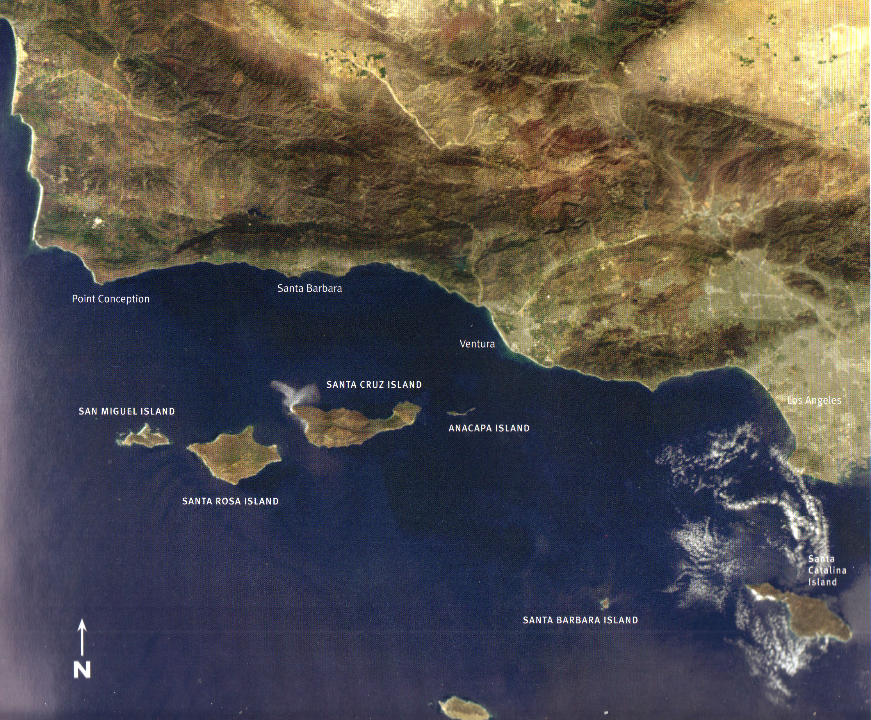
From then on, I was eager to find some way of getting out to the islands. Santa Cruz Island, the largest, was mostly privately owned by the Stanton family of Los Angeles. The second largest island, Santa Rosa Island was owned and operated as a cattle ranch by Vail and Vickers, whose boats sometimes brought cattle to the mainland at Santa Barbara. San Miguel, the northernmost island off Point Conception, a windy place surrounded by a turbulent sea, was famous mostly for its huge population of seals and sea lions, drawn to the cold, upwelled water rich in nutrients.
I remembered from the family stories that both my mother and father as children had visited Santa Cruz Island. Before she died in 1981, I asked my mother to tell me her story.
On lined yellow paper, she wrote in her spidery hand: “When I was a small girl the trip to the Santa Barbara islands was a great adventure. One time my mother, grandmother and little brother went to Santa Cruz Island in a fishing boat. As The Channel was very rough that day, the deep dips into the troughs of the waves were terrifying to all of us. The kindly Italian fisherman tried to reassure us but we did not retain our equilibrium until we landed safely on the island.
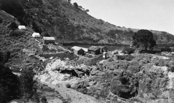
Eaton’s Resort at Pelican Bay – 1920
At that time, the only accommodations on Santa Cruz Island consisted of tents with wooden floors.* At night we could hear the wild hogs rooting around in the under brush which was scary. The food in the dining tent was plain but good with plenty of fresh fish.
A highlight of our stay was the trip into the blue caves. One entered their inner fastnesses in row boats. These caves were accessible only at low tide and in quiet waters. Within them, the water was a brilliant blue which became darker the further in we ventured. It was thrilling to trail one’s hand which yielded a ghostly phosphorescence. Back home again I had much to tell my less venturesome playmates.” – Elaine Adrian Willoughby
Sea Cave
I knew less about my father’s trip (or trips) to Santa Cruz Island. There was something about a borrowed Boston whaler, and that the wild boar they shot was so tightly wedged in a narrow canyon that they had to butcher it on site and deliver it piecemeal to the boat.
I can imagine that Santa Barbara in the early 1900s, with less than 10,000 inhabitants, was an ideal place for a boy to grow up. He and several co-conspirator built a shack up San Roque canyon until a wild-fire destroyed it. I have a small photo of him as a young teenager with his dad on a mountain trail, he with high boots, a slouch hat, and a canvas rucksack hanging heavily off his shoulders.
Now it was my turn.
TWO WHO CELEBRATE THE NATURAL WORLD
Hugh examines a damsel fly
HUGH RANSON – birder, teacher, and writer who writes the Saturday column “Bird Watch” for the Santa Barbara News Press. He began his bird watching as a boy in England.
In the last five years, he has taken up the study of dragonflies and during lunch breaks can often be found at a local pond with his net and camera.
Be sure and read an except from “Bird Watch” in the Blog “This Time for Work.”
Bill Dewey in his plane at the Santa Barbara airport
BILL DEWEY Bill has been photographing the California landscape since the early 1970s and has been flying since the 1980s. Some of his favorite subjects include the California Channel Islands, Carrizo plain, Baja California, and the rural California landscape. His work is widely published and shown in various galleries and museums. His aerial photos begin each my Santa Cruz Island blogs.
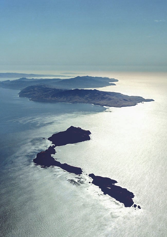
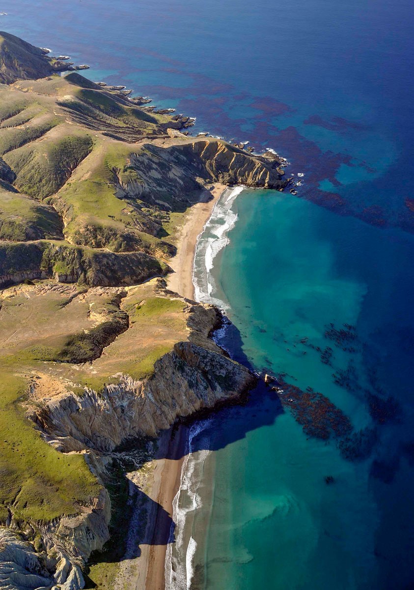
The Channel islands from the air, with Anacapa in the foreground, Santa Cruz, Santa Rosa, and San Miguel Island in the background. Photo by Bill Dewey
SANTA CRUZ ISLAND – THEN AND NOW
The Archipelago of the four Northern Channel Islands included westernmost San Miguel Island, Santa Rosa Island, the mountainous Santa Cruz Island, and finally little Anacapa with its “tail” of broken islets trailing behind. Now that I’ve settled in Santa Barbara where I most likely will conclude my life, I view the islands from the mainland, always drawn outward toward them. I see them from my daughter’s house high on the hillside above Mission Canyon, most often reclining on the horizon in their bed of haze. Sometimes the fog obscures them from view altogether, or there are times when the vapors are swept away by a dry north wind, and I can clearly see their cliffs and coves.
Over the years I’ve collected my own experiences of the islands. Last year, I crossed the choppy Channel on an Island Packers boat out of Ventura Harbor. I was lucky enough to have secured an invitation to the annual mass, thanks to Marla Daily, the head of the Santa Cruz Island Foundation.
Mass at the chapel
But my awareness of the islands, particularly Santa Cruz Island, began as a child when I read The Channel Islands of California, by Charles F. Holder, published in 1910 which I claimed from my parents’ library. The book with its turquoise-blue linen cover and the decorative drawings of the flying fish is now on my Santa Barbara bookshelf. I still love to reread the description of the ride in a horse-drawn carriage up the wild canyon to the Central Valley from the anchorage at Prisoners’ Harbor.
From “The Channel Islands of California”
Quoting from the book: “From the sea, Santa Cruz Island is a jumble of lofty hills and mountains, with deep gorges and canons winding in every direction.
Hidden away in the very heart of the island is an ideal ranch, with a pronounced foreign atmosphere, in a climate as perfect as that of Avalon to the south.”
“Seated in the trap, with our host holding the reins, we turned into a gorge… the road wound upward; the horses now splashing through the summer stream beneath gnarled and picturesque oaks, now out into the open, where the sun poured down through rifts in the cañon beneath a sky of tender blue, plunging into the narrow cañon again, where walls grew lofty and precipitous, shutting out the glare of sunlight; …”Three miles of this, and the charming canon road came to an abrupt end. The canon sides and the mountains suddenly melted away, and the horse dashed into a long, rolling valley, where the air was like velvet on the cheek and an incense of flowers and vines filled the nostrils.
But last Sunday it was in the cab of battered green truck driven by one of Marla’s relatives. Several trucks of various vintages were waiting for passengers who had disembarked from the boat tied up at the end of the green trucks brought us up from the boat long pier. I carefully climbed up the ladder, aided by the crew, to the rough planks of the pier. I was more uncertain than usual because I had fallen on the deck of the boat when a sudden lurch had tossed me down on my back.
Approaching the pier at Prisoners’ Harbor
I’d been pulled back upright without apparent injury though my confidence in staying upright had been challenged.
The streambed was dry the first mile or so but then we encountered water. We forded the stream several times “before the canyon sides and the mountains suddenly melted away.”
The ranch house in the Central Valley. Photo by Sally Isaacson. Courtesy of the SB Botanic Garden
It was different from when Holder had made the same trip a least a hundred years earlier. No longer a working ranch, most of the island now belongs to the Nature Conservancy. The vineyards which once traced the contours of the hills had been removed. Gone were the horses, cattle, and sheep. The ranch house was no longer ornamented with the iron grilles forged in the ranch forge.
The people this day were mainlanders who had come to enjoy the annual festivities, attend mass, drink wine and feast on the barbecue before returning to the mainland on the four o’clock boat.
A trip on Island Packers from Ventura to Santa Cruz Island
Leaving the mainland behind
Approaching Santa Cruz Island, Anacapa to the Left
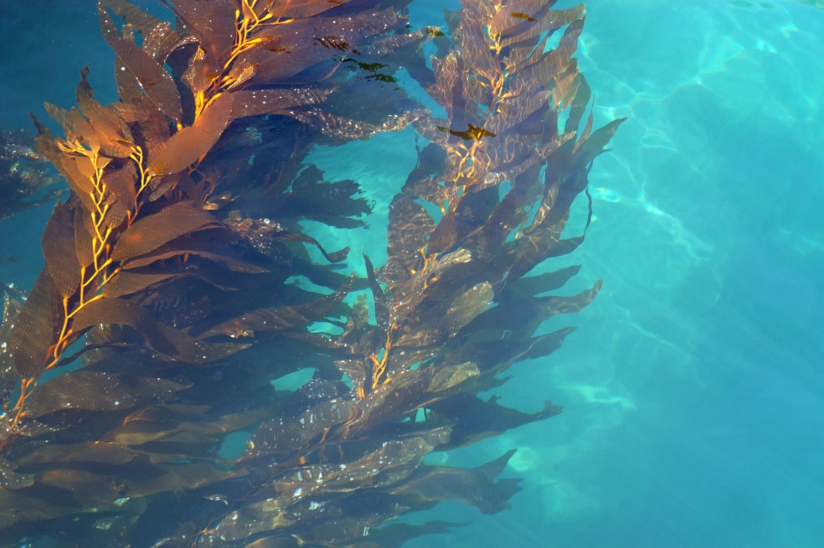
Giant Kelp. Photo by Bill Dewey
Hills surrounding the Central Valley
I mostly kept to myself, listening for bird songs and calls and finally spotting an Island fox. Mostly I tried to recapture in these dry hills the island of my dreams.
THIS TIME FOR WORK
(First published as “Island Exuberance” for Santa Barbara Magazine spring 94)
Near Christy Ranch. Photo by Bill Dewey
I’m drawn to all islands, but especially to those that lie off a mainland shore, like the Channel Islands. At times they beguile you, half hidden behind veils of fog, and at other times they abandon subtlety, revealing in dazzling detail their pale sea cliffs and shadowed canyons.
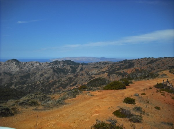
High road on the red rock ridge with Santa Rosa Island in the distance Photo by Steve Windhager Courtesy of the SB Botanic Garden
I don’t pretend to understand the power these islands have on me. Maybe it was the epic tales of sea voyages and island landfalls that fueled my imagination as a young reader. Or the stories told by my parents, who were raised in Santa Barbara. I made my first crossing to Santa Cruz Island, the largest island of the northern group, 25 years ago on a three-masted schooner. Since then I have managed to return often, usually as a participant in natural history groups or as a Nature Conservancy volunteer. Last spring, I volunteered as a plant monitor, and saw the island once again, this time from the back of a jeep as we lurched over ridgetop dirt roads on our way to inventory plants.
To the north was a mountain range of ruddy-colored volcanic rock. To the south toward the open sea rose a conical mountain peak of dazzling white rock know as the Blanca Volcanics. The island is, in fact, made up of two disparate land masses, that came from different directions and are sutured together by a fault know as the Central Valley. It is not hard to believe that this wild jumbled Technicolor landscape is still on the move, sliding northward toward the Aleutians. Some 18,000 years ago when the ocean level was lower, all four islands of the northern group were joined together in one super-island scientists refer to as “Santarosae”. Through the islands’ evolution many configurations developed, but they have not been joined to the mainland, at least not in recent geological times.
The plants and animals we see on Santa Cruz Island today came on the winds, were carried by ocean currents, or were brought ashore by human visitors. Salamanders and other stowaways came ashore on the same log rafts that the Chumash fashioned into canoes. Once on the island, many animals and plants have evolved distinctive forms
Island Fox. Photo by Joni Kelley. Courtesy of the SB Botanic Garde
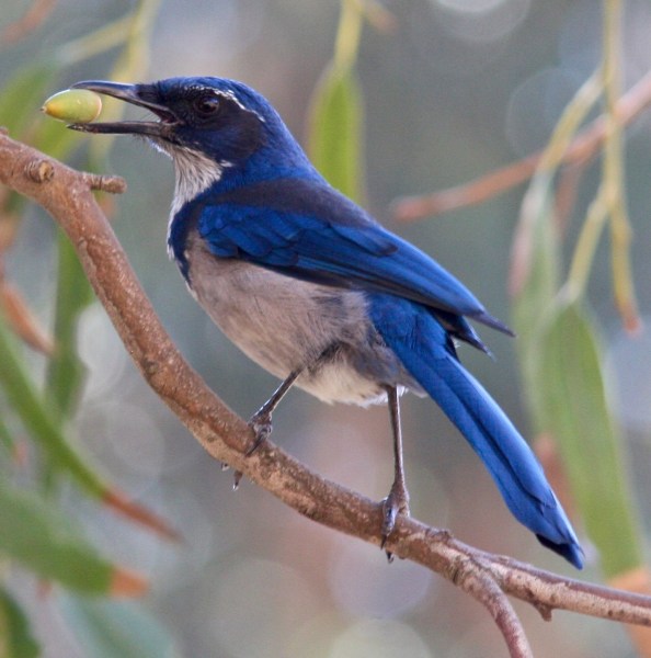
On our trips around the island, we saw the little island fox that weighs barely three pounds. Other species are larger than their mainland cousins – examples of what scientists call gigantism. The Santa Cruz Island jay, for example, is bluer and 25 percent larger than the mainland Scrub Jay. Toyons and elderberries are shrubs or small trees on the mainland, but they can grow to 40-60 feet on the island. Maybe it’s the temperature, moist climate or lack of competitive species. I call it island exuberance. There are fewer species too, fewer kinds of birds, two types of snakes, and no burrowing animals at all. The four terrestrial animals are endemic, meaning they are found no place else.
This article and photo was excepted from “Bird Watch,” published each Saturday in the Santa Barbara News Press and written by Hugh Ranson.
Santa Cruz Island: the California Galapagos
One of the acorn-eating island scrub-jays. Photo by Hugh Ranson
I recently ventured out to Santa Cruz Island in search of migrant birds. While I didn’t see a great variety of migrants, there were enough resident species to keep me well entertained. Island foxes, which have made quite a comeback, trotted about throughout the day, seemingly unconcerned by human intrusion. Another island endemic, the island scrub jay, was much in evidence.
Hundreds of birders venture out to the island each year to see the jay. Why? It’s a species found nowhere else on earth. The island scrub jay was once considered conspecific with the California scrub jay, the familiar jay found commonly along our coast. It was officially recognized as a separate species in 1998. It is larger, much more brilliantly blue, has a larger beak, a different voice, and different social habits than its coastal cousin.
There are at least a couple of theories as to how the jay made its way to the island and began the slow differentiation from the mainland species. Jays are weak fliers and do not travel across large bodies of water. One thought is that jays made their way by hitching rides on floating vegetation. Another is that during a period of glaciation, when sea levels were lower, jays were able to cross the much narrower channel. At any rate, it is thought island jays have been isolated from the mainland for over 150,000 years.
Santa Cruz Island has a healthy population of jays estimated at 2,300 individuals. However, this population is considered vulnerable because of the small area of the island. There is the constant danger of fire, and more menacing still, the threat of West Nile Virus, to which corvids (jays are in the crow family) are particularly susceptible. Because of this latter threat, many of the jays have been captured and vaccinated.
It seems the island scrub jay is perhaps even more remarkable than we realized. Recently, biologist Kate Langin made a discovery that turned a theory of evolution on its head. She found that there are two separate populations of jays on the island, one that favors oak woodland, and one that inhabits pine forests. The oak-loving jays feed largely on acorns and have evolved shorter, stouter bills. The pine-inhabiting jays have longer, narrower bills, adapted for extracting pine nuts from pinecones. Even where pine and oak woodland are mere yards apart, the two populations appear to remain separate.
Charles Darwin theorized that in order for species to differentiate, like the famous Galapagos finches, there needs to be geographic separation. The island jays appear to be the first known instance where this theory doesn’t hold.
If you haven’t yet made it out to Santa Cruz Island, it’s time you did! Island Packers of Ventura run daily trips to the island. It takes a little over an hour to reach the island, and there are excellent opportunities for viewing marine mammals and birds on the crossing. There are two anchorages served by the company, Scorpion and Prisoners. You have an excellent chance of seeing the jay at Prisoners. It used to be that they were rarely seen at Scorpion, but in recent years they have become more common there, frequently foraging in the campground. I saw several there on my last visit. Scorpion also has many choices for coastal walking trails
Ironwood Grove. Photo by Steve Windhager. Courtesy of the SB Botanic Gardens
The scalloped-edged ironwood leaf resembles the splayed, scaly foot of some prehistoric bird. The light ripples as the tall trees sway in the sea breeze. In the presence of these shaggy-barked survivors, you can imagine these to be sacred groves. Islands have a way of compressing — and enlarging – human emotions, and island tales are replete with mysterious and sometimes tragic human stories. In the singularity of an island, you confront your own separateness, you own uniqueness. It’s been almost a year since my last island visit. Every day here on the mainland, I climb the hill behind my house to look seaward, hoping for a glimpse of the dark shapes on the horizon – elated when I can see them, a little lonely when they are obscured by fog or clouds.
TWO JAYS
Island Shrub-Jay
California Shrub-Jay
The Island Shrub-Jay was once thought to be a sub-species of our common coastal California Shrub-Jay, but now is recognized as a separate species. The Channel Islands have been separated for eons from the mainland. Jays being weak flyers, and with 25 miles of channel separating them, the Island Shrub-Jay has had a long time to develop its separate characteristics.
The Island jay is over all bigger (the beak especially so), the plumage is brighter and bluer and its cheek is near-black instead of gray.
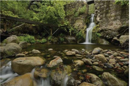
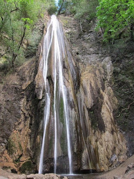
Sometimes it’s only a few thin bands of water dropping 164 feet. Other times it’s a gossamer tracery of water more mist than substance. It nourishes families of mosses and ferns growing on its walls. Only after a rain, does Nojoqui Falls aspire to something grander.
The falls (pronounced NAW- ho – wee) are named for a Chumash village “Naxuwi” once nearby.
When my granddaughter asked me what I wanted for my birthday, I said: “A day trip with you.” We talked about where and decided on a drive up the coast and inland to Nojoqui
Falls County Park, and then lunch at one of the good places in the Santa Ynez Valley. I wanted to walk along a creek and possibly even see falling water while it was still spring.
Driving up along the coast is a treat in itself. Once you’ve cleared the outskirts of Goleta you are in full view of the ocean and if the day is clear enough, you can see the profile of the islands on the horizon.
On the right, the Santa Ynez Mountains make a formidable barrier to the sea and its cool breezes. We passed three beach parks. On the landward side of the freeway, the beaches become canyons. Though beautiful on its own, the landscape stimulated memories – El Capitan Beach where grandson Stuart always wanted his birthday to be celebrated with a campout.
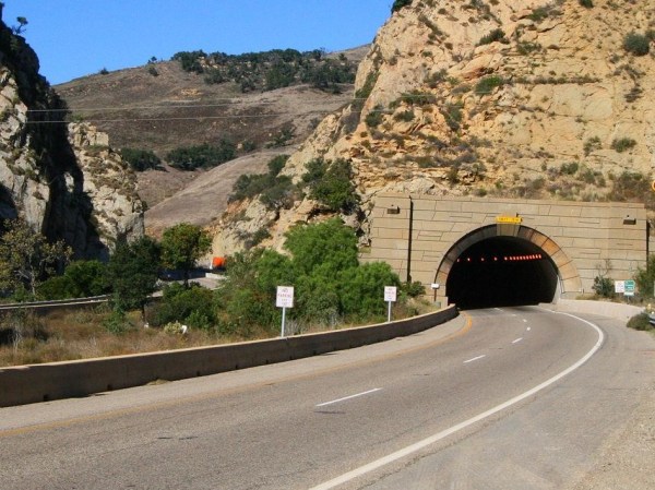
Just beyond Refugio Beach, the highway swings inland where ahead, the mountain wall is pierced by the Gaviota Tunnel. I thought about all those years when Santa Barbara could only be approached easily from the south.
At the sign “Nojoqui Falls County Park,” we left the noisy highway and dropped down to the Old Coast Highway and Alisal Road to the peace and quiet of farmlands. Once horse pastures, organic produce now grows in the soil enriched by manure.
Skirting the western edge of the mountains, we rounded the corner to the lush, north-facing slopes, the rainiest place in the county. How different from the south-facing slopes above Santa Barbara where the mountain slopes are dominated by bare sandstone and chaparral.
When we turned into the park with its broad meadow and a scattering of trees, Caroline said: “This reminds me of Yosemite Valley.” I could see her point except that when every detail of a beloved place like Yosemite is so perfectly embedded in my memory, nothing can compare.
We drove up to the end of the road where a few cars were parked. At the base of the canyon, a short trail leads up to the falls.. Starting up the trail I was transported to the Berkeley Hills where bay trees also form arches of fragrant leaves and the sun shines through the thin leaves of the big-leaved maples. The creek burbling over dark rocks reminded me of the dark-gray basalts of home.
The final ascent on stone steps to the base of the falls looked damp, making them especially perilous for my old legs. A bench at their base invited me to sit a while, let my granddaughter
Warbling Vireo
trot ahead while I listened to the creek and the cascade of Warbling Vireo songs spilling down from the bay trees overhead. Click here to listen to their song.
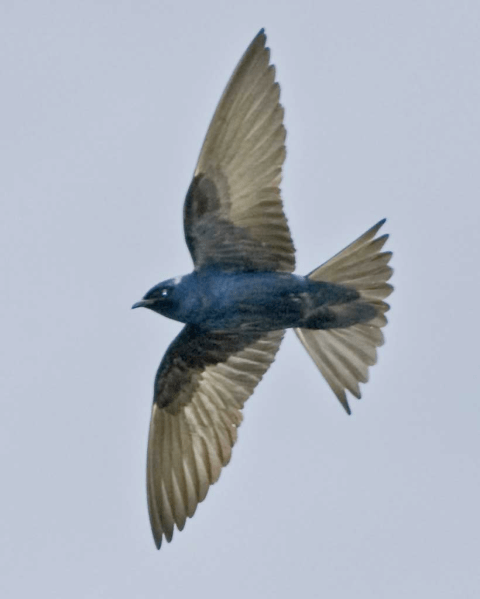
Purple Martin
Purple Martins are our largest and highest-flying swallow. They perform breath-taking acrobatics when hunting insects. At the park, martins ignore man-made boxes in favor of holes in the sycamore trees.
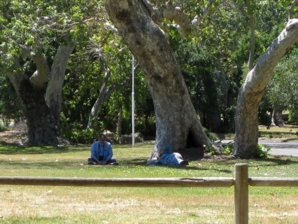
Three weeks later with Berkeley birding friends, Bob Lewis and his wife, Hanno, we returned to Nojoqui Falls park to find the Purple Martins. Bob is sitting on the left. The heap on the right is actually me lying on my side watching martins in flight. Stretched out, has become my preferred position for watching birds of the sky and for general cloud-spotting.(I highly recommend to others who love clouds “The Cloudspotter’s Guide by Gavin Pretor-Pinney – the founder of The Cloud Appreciation Society)
Varied Thrush
Now we will be leaving the park to the summer crowds, returning in the fall to see the winter birds like the beautiful Varied Thrush.
If you have lived a natural life say as a manzanita bush on the slope of the San Ynez Mountains you will understand the true meaning of summer. You will have grown new foliage or lengthened the leaves you have during late winter or early spring. You will have flowered and welcomed the bees. Now the flowers have turned into fruit, it’s time to let them ripen in the warm sun of the long days. It’s a season for repose or maybe deepening, as your tap root reaches down further to find water.
I’m drawn to canyons with their cool shade and generous vegetation, especially in this dry, mostly mountainous country of sun-struck rock.
And so is all life. Birds and other animals come to where there is moisture, abundant food, and places to raise young.
A canyon trail
The view from my apartment above Oak Park
I look northeast to the Santa Ynez Mountains. The mountains are a transverse range, one of several ranges so named because they trend east and west rather than the usual north-south of most coastal mountains. The town of Santa Barbara occupies the narrow alluvial plain between the ocean and the mountains
The mountains are composed mostly of pale sandstones often embedded with fossil shells from the distant past when the mountains were under a warm sea. Reflecting the low winter sun and protecting the region from the chilling north winds, the mountains have a profound effect on the local climate.
My bedroom window perfectly frames Montecito Peak, the most symmetrical of all the named Peaks. At midday, when the mountains are evenly lit, they resemble a jigsaw puzzle of pale rock and mats of olive green chaparral. I look hard to try and distinguish a canyon, but it’s when the sun is low in the sky before sunset that the mountains reveal their contours. Purple shadows fill the canyons while ridges and peaks glow in the late light. I learned by studying a map that the deep shadow in the saddle west of Montecito Peak is the top of Cold Spring Canyon.
Montecito Peak on fire, Oct 29, 2015
Most canyons have a stream, often an ephemeral one which appears only briefly after a rain. Others, like Mission Creek, are considered perennial, but in fact water persists only in the foothills and mountains. Because of the steepness of the Santa Ynez Mountains, most streams, beginning as springs near the top of the range, may drop four thousand feet from their headwaters in a few miles to where they join the Pacific Ocean.
My plan was to hike several of the canyons so I could write about them with affection and authority. On my first try to the San Ysidro Trail on the almost level Ennisbrook Trail, I fell and cracked my ribs.
I saw two solutions – send my two grandchildren with their stout hearts and strong legs into the canyons where they regularly walk. Or I could narrow my canyon and stream observations to Mission Creek, one of the most accessible of the perennial stream which runs (when it does) through Oak Park just below my apartment. So Mission Canyon it is.
Mission Canyon and its Creek
Mission Creek and its canyon have a rich history dating back to the Mission days in the late 1700’s when the waters were captured behind a stone dam built with Indian labor in 1803 and stored in sandstone reservoirs just above the mission itself. The water irrigated the sloping garden of fruit trees, vegetables and wheat. When Spain defeated Mexico in 1830, the missions lost their authority and most of the Indian labor. The garden quickly fell into ruin along with many of the adobe buildings.
At the top
Like most of the streams which flow down the south slope of the Santa Ynez Mountains, Mission Creek begins as springs near the ridgeline and then emerges as a series of cascades and pools, accessible from the Tunnel Trail.
Following James Wapotich’s directions in his weekly “Trail Quest” column in the News-Press, I located where the Tunnel Trail begins along East Camino Cielo Road, just beyond the intersection with Gibraltar Road. The trail is marked by an aging metal sign and three large boulders across the dirt road. The trail – the dirt road – continues just beyond the level section when it becomes a narrow trail dropping steeply down to where Mission Creek begins. The Falls are a popular destination for hikers, most hiking up from Tunnel Trail off Tunnel Road. I’ve never hiked up far enough to reach the falls so I have to rely on the reports of others and the photos they took.
Mission Creek Falls
At The Botanic Garden
It’s in the Garden where most of us become familiar with Mission Creek. Before the present four-year drought, regular releases from the Mission Tunnel (which brings water from Gibraltar Reservoir to Santa Barbara) kept the creek refreshed, so one season seemed like another. Now the stream is mostly small ponds, growing green with algae.
Standing on the uneven stones at the top of the Indian dam is a good place to look up and down the steam and to admire the
Mission Dam
feat of building the dam with hand labor. Once, the stored water was carried down stone aqueducts to the Mission where it not only provided irrigation and drinking water, but filled the stone basins (still there to see above the Rose Garden) where hides were soaked prior to tanning.
Rocky Nook Park
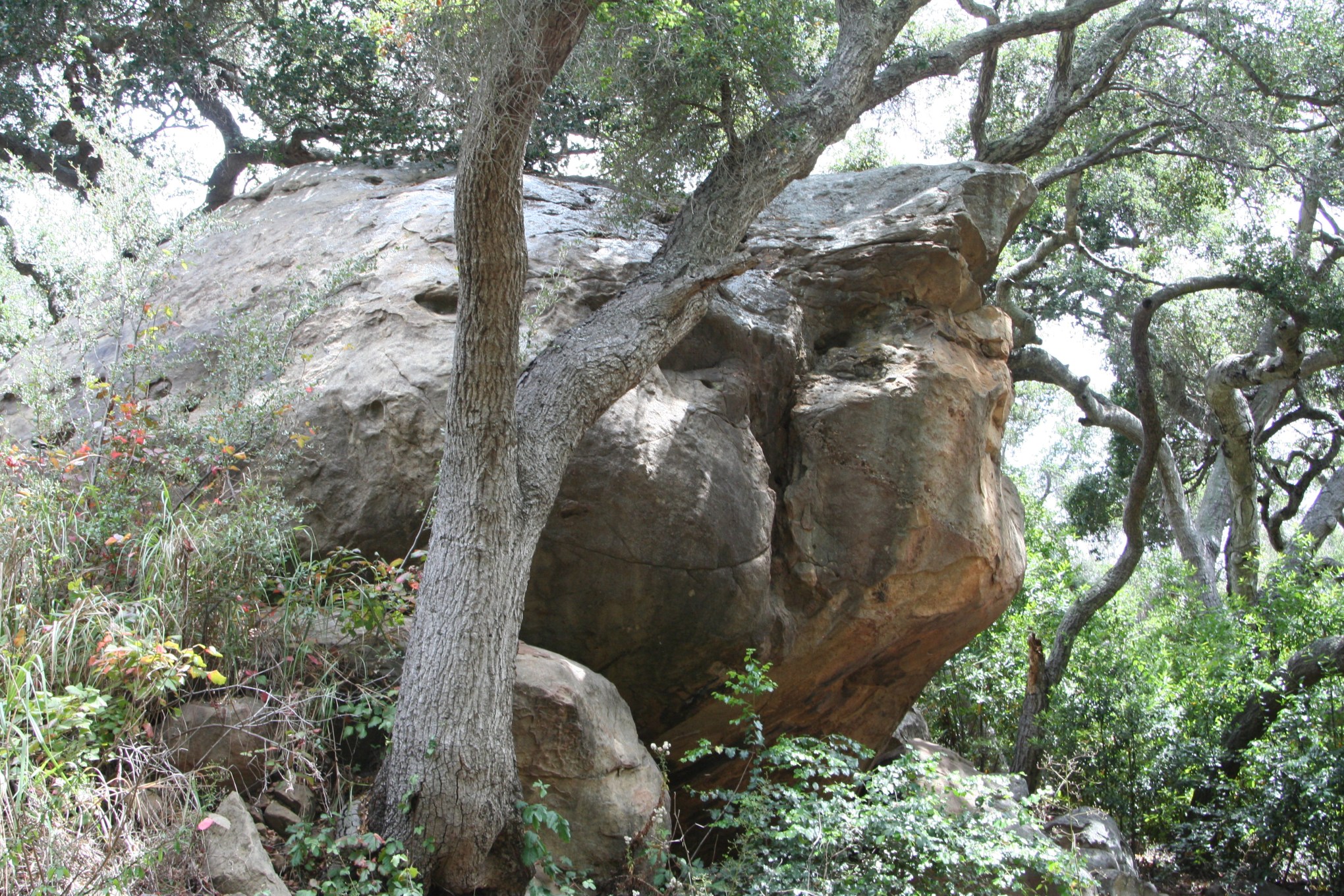
Boulder families
A couple of blocks above the Mission is a charming county park – known by the locals simply as Rocky Nook. And rocky, indeed. Boulders, scattered generously everywhere, were deposited a thousand years ago by a debris flow that roared down the canyon depositing boulders along the way. A Chumash Indian legend says the boulders are the bone remains of the Indians
Alder Tree
drowned by the slurry of water and sediments. I felt as if I were photographing family groups. In late May at the
Alder Tree with catkins
beginning of the long dry season, the creek is surprisingly active though its flow will most likely decline as the season advances.
At Oak Park
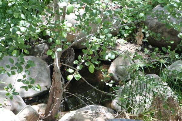
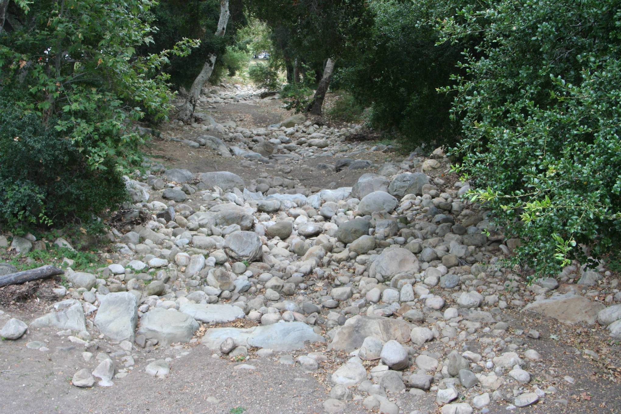
Since I moved to Santa Barbara three years ago, a four-year drought has reduced Mission Creek at Oak Park to mostly a dry creek bed. Only after a rain of an inch or more would the creek come to life as a muddy noisy, torrent which finally reaches the sea by curving a path across the beach just south of Stearns Wharf.
Within a day, the creek at Oak Park becomes a series of clear pools joined by rivulets of gurgling water. It is then that I walk slowing along its banks, imagining the water circulating through my veins, refreshing my worn and tired body. And I would then know deep peace. The following day, the creek disappeared leaving behind only drying mud where the pools had been.
The creek bed once again is laid bare and often weed-filled. By late spring, the stream even in the foothills at the Botanic Garden, is often reduced to a few algae-filled pools.
Mission Creek leaves its canyon just below the Garden where it is joined by Rattlesnake Creek. Together they meander several miles across the gently-sloping plain (called by geologists an alluvial fan) to the ocean. Over the years, the creek has flooded the town several times during the rainy winter months.
My father, who as a boy lived between Oak Park and Cottage Hospital, remembers those
Dad’s boyhood home on Castillo Street
times when the only high spot in their neighborhood was their garden, where the neighbors came and stood until the flood waters receded. During the floods, the creek waters filtered slowing down through the rock and soil replenishing the groundwater. Today, the creek, often contained by concrete sides, seldom floods, so it flows directly into ocean carrying with it pollutants, often closing for a time the surrounding beaches as unsafe for swimming.
Oak Park is not a nature park, it’s a people park where neighbors walk their dogs and on weekends, it’s crowded. Piñatas are hung from the oak branches, musicians tune their guitars and horns, kids play in noisy swarms, and men sweat over the barbecues. In the winter when the days are short and sometimes rainy, Oak Park returns to a more natural environment.
Mission Creek Outfall
Mission Creek Outfall
Black Skimmer fishing
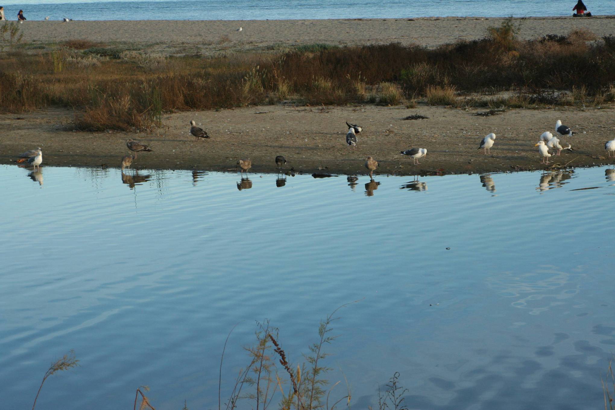
Most of the year, the creek trapped behind its sand berm from continuing to the ocean, forms a quiet lagoon favored by water and shorebirds, especially during the winter. When the creek is in flood stage, it carves a curving course through the sand to the ocean.
Looking back
My love of canyons goes back to a childhood living in the Oakland Hills. There were no houses across the street because at the bottom of the slope was an electric train, part of the Key System, which ran across the Bay Bridge to San Francisco. The dense slope on the other side of the track was a no man’s land until I was old enough to venture further afield. What drew me there was an ethereal bird song, I didn’t recognize.
Swainson’s Thrush
The slope was too steep to navigate on foot so I slid on my behind through what I would later discover was mostly poison oak. After an almost vertical slope of slippery clay, I found myself at the edge of a creek. And there was my bird, silent now, who fixed me with it’s round eye, made even rounder by a circle of white feathers. Late in the spring, the creek was reduced to a series of dark pools, laced together by threads of running water. Water striders skated across the surface while dragonflies darted about occasionally touching the water.
I couldn’t stay away from this newly discovered world until a painful rash spread across my body after each foray.
Lake Merritt, Oakland
I later learned that the creek was called Trestle Glen Creek or Indian Gulch Creek named for the Ohlone villages along its margins. Instead of flowing into the ocean, the creek brought its water to Lake Merritt, a tidal sanctuary with an amazing array of winter water birds, attracting enough attention so it became the first waterfowl sanctuary in the country.
In my twenties, we moved to the Berkeley Hills and my stream became Strawberry Creek. The stream like so many coastal streams rose in springs near the top of the Berkeley Hills, flowed through the Botanical Gardens, which I came to love and where I meet a dear friend and with him led monthly bird walks. The garden was paradise and a number of birds thought so too. In the spring, the bird song was almost overwhelming. Thrushes again, including the dearest of all – the American Robin, the Black-headed Grosbeaks, Warbling Vireos – on and on – singing an intoxicating symphony of melodies unlike any other stream canyon I know.
I have also learned a new concept for understanding ones place on the planet by determining ones watershed. Our house was on a slope near the top of the Berkeley Hills where the most of the water drained toward Strawberry Creek which I liked to claim as defining my home place.
Since moving to Santa Barbara three years ago, my watershed is unequivocally Mission Creek, as was it for my parents who lived nearby more than a 100 years ago.
Phila’s Team: George Dumas, Webmaster Nancy Law, Editor Roger Bradfield, Artist
It sits looking
Over harbor and city
On silent haunches
And then moves on
–Carl Sandburg
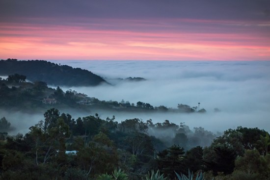
I’ve lived in coastal California for all of my 87 years, so you think by now I would have developed at least a tolerance for the fog which arrives each summer. But I’m one of those unfortunate people whose moods are dictated by the weather. Awaking to sunshine fills me with good cheer. A gray beginning sets a similar mood for the morning.
Yes, I’ve heard the arguments – fog delivers at least some moisture in this driest of seasons during perhaps this most serious of droughts. And the cloud cover protects plants from the desiccation by the summer sun.
I’m also aware that taking the perspective of a naturalist delivers me from being a victim of moods (moods are nice enough when they are cheerful ones). I’ve spent the last few days doing research, reacquainting myself with my library including historical books like “Up and Down California,” Brewer’s fascinating account of doing a geographic and geological survey of the state in the 1850’s, and going a century back to the classical account of California’s coast by Richard Henry Dana in “Two Years Before the Mast.” I’ve also been mining Google for gems of information.
Dana didn’t mention fog as he was more concerned about the winter when the anchored ship could be caught by a southeast storm gale and be blown ashore before they could set sail for the open ocean.
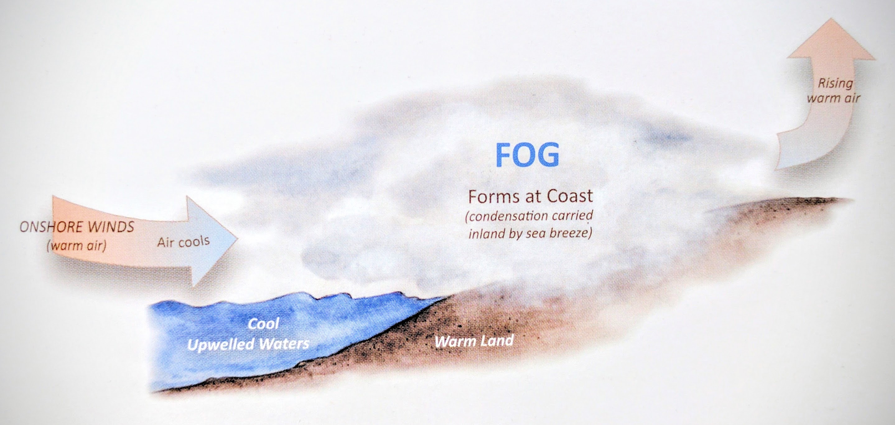
At the risk of sounding pedantic, here are some basic facts. Our fog – advection fog – comes mostly in the summer months when the Northern Pacific High is in command. That zone of high pressure that squats over the eastern Pacific, fends off storms that might come in from the north, and establishes summer wind patterns. In the late spring and early summer, the wind picks up speed and blows down the coast. The wind displaces the warmer surface water causing an upwelling of the deeper, cold water. When the warmer wind passes over the chilly water, the moist air condenses into tiny liquid droplets suspended in the air, forming fog.
The movement of fog onshore on a typical summer day (“A Naturalist’s Guide to the Santa Barbara Region” Joan Easton Lentz. Illustrator: Peter Gaede)
Often the fog is drawn inland by the low pressure lying over the hot the Great Central Valley. The fog usually retreats back to the immediate coast where it may persist all day, and sometimes for days on end. In Santa Barbara, those foggy days may be called May Gray or June Gloom. In Northern California the winds and chill air at Pt. Reyes makes it one of the foggiest places in the world with an average of 200 foggy days a year.
I favor those late summer and early autumn days of decreasing coastal fogs when the Pacific High begins to slowly shift south allowing for the possibility of an early rain coming down from the north. Or when humidity sometimes moves north bringing the possibility of a thunderstorm and wonderful cloud effects. Exotic weather heightens one’s senses.
I’m also reading about how coastal fogs along the north coast have allowed the redwood forest to persist. Once, when the climate was much wetter, redwoods were common over much of the continent. But as the climate became drier and cooler, the redwood forests retreated to a narrow band along the immediate coast of Northern California visited by ocean fogs in the summer.
I once read that sunny California has more fog than any other state when you consider that the coast in the summer is often foggy and in the winter, damp, ground-hugging tule fogs covering the Great Central Valley can blot out the sun for days on end until the next rain storm sweeps the fog away for a time. The so-called radiation fog often follows the rain when the earth is both chilled and damp and the drier air above it condenses, forming fog. I remember once driving across the Sacramento Valley at night and I could see that the fog came up to the cow’s belly, leaving its head in the clear.
Back to Santa Barbara: In his journal; ”Up and Down California” William Brewer writes on Tuesday, March 12 (1861). “Still foggy and wet. This weather is abominable – now for nearly two weeks we have had foggy, damp weather, tramping through wet bushes, riding in damp, foggy air, burning wet wood to dry ourselves, no sun to dry our damp blankets. I find that it makes some of my joints squeak with rheumatic twinges. Went out this morning, found it so wet that we had to return to camp”.
Five days later on Sunday Evening, March 17, he writes: “We have had a clear hot day, after two week’s fog, and have improved the opportunity to dry our blankets and clothes, botanic papers, etc.”
I don’t recall in my four years of living in Santa Barbara of having a foggy spell in March. What does ring true is the strength of the sun. Even on foggy days, as the fog begins to thin one can feel the heat of the sun. I remember being warned as a child, that I could be badly sunburned by the sun in a light fog.
I’m not sure about this, but it’s my impression that the west coast of the continents at our latitudes often have summer coastal fog. In the case of Peru, Chile and Namibia in Africa, these are deserts with little or no rain, and no surface or groundwater. A certain Namibian beetle sleeps with its hindquarters raised and in the morning shifts its position to allow the condensed moisture to run into his mouth for a drink. Incas, living on the barren slopes off the west-facing Andes, after observing that pots under shrubs and small trees filled with fog drip, learned to string up nets made of small mesh which would sift drifting fog, collecting up to a hundred gallons a day.
In the Bay Area where I lived, researchers measured in the rainless summer the equivalent of 10 inches of rain under the pines and eucalyptus along the ridgeline of the foggy Berkeley Hills. I noticed how on my summer walks in the grasslands, yellow and dry by May, I could count on a circle of fresh green grass within the drip line of each tree. The long narrow leaves of the eucalyptus and the slender pine needles did an especially efficient job of combing out moisture from the drifting fog.
Harvesting fog
Why not string a series of nets along Twin Peaks in San Francisco? Unfortunately such a meager harvest could only supply the needs of a small neighborhood. But there are small villages in the arid west coast of South America and elsewhere, where enough water was collected with fog nets to grow crops, irrigate orchards and have enough left over for personal use.
One such community is Bellavista, a village of 200 people on the dry slopes above Lima, Peru. With almost no rain, no river, or groundwater, the village had to be served by anto expensive water trucks from Lima.
Conservationists Kai Tiederman and Anna Lummerich, working with a non-profit supported in part by the National Geographic, showed the villagers how to construct the fog catchers — nylon mesh stretched between poles. The villagers did the heavy work, carrying sand bags 800 feet up the steep hill to stabilize the poles and to build pools to store the collected water. With the wind blowing the heavy fog through the nets they can now collect 600 gallons a day.
The newly-planted 700 tara trees will be able to eventually collect their own water. Tara trees produce valuable tannin.
Okay, I’m convinced. Bring on the fog and no more grumbling about gray mornings.
William Brewer’s first view of Santa Barbara in 1861 was from the back of a mule. Brewer was part of the California State Geological Survey responsible for conducting a geological and topographic survey of the state, with an eye on identifying mineral resources.
The Survey Party
With gold fever having subsided, the new state legislature wanted to have a systematic survey of state’s resources. The well-known geologist, Josiah Whitney, headed the survey. William Brewer’s title was that of “Principle Assistant, in charge of the Botanical Department.” He was responsible for the fieldwork and for keeping detailed records of what was collected, measured, and observed.
With indefatigable energies, an insatiable curiosity, Brewer keep not only the field notes but managed a voluminous correspondence which became the basis for his journal: “Up and Down California in 1860 – 1864,” edited by Francis P. Farquhar and published by the Yale University Press in 1930. My copy, a beautiful edition generously illustrated, was inscribed to my father by Mr. Farquhar. Mr. Farquhar at the time was the editor of the Sierra Club Bulletin and himself a mountaineer and author.
William Brewer and his party departed from Boston, not on a sailing ship, but on a streamer bound for Panama. They crossed the isthmus by train to board another steamer for San Francisco. Like those before him and those after, he was overwhelmed by the beauty of the Bay and impressed by the substantial look of the young city. Brewer compared the early November day, to the finest Indian summer day on the east coast, “but without the smoke.“
From San Francisco, the party steamed south to San Pedro near Los Angeles. After leaving Los Angeles, they travelled north, exploring the coastal terrain, arriving at Santa Barbara region the end of February.
East of Santa Barbara, Brewer climbed a high ridge alone. He discovered a variety of shells weathered out of the rocks “as thick as any seabeach and in good preservation.”
I cannot describe my feelings on that ridge, that shore of an ancient ocean. How lonely and desolate! How many decades of centuries, have elapsed since these rocks resounded to the roar of breakers, and these animals sported in their foam … no human being was within miles of me to break the silence. And then I felt overwhelmed with the magnitude of the work ahead of me … doing field work in this great state, a territory larger than New England and New York, complicated in its geography.
They arrived at the town of Santa Barbara on March 7. The steamer was to leave that night for San Francisco. With only two steamers a month, Brewer comments on Santa Barbara’s isolation where only horse trails connected the community to other settlements to the north. The first, rough wagon road north would be completed later in the spring.
Brewer’s observances about the “decadent town” were much like Dana’s thirty years earlier.
The mission was founded about the time of the American Revolution – the locality was beautiful, water good and abundant. A fine church and ecclesiastical buildings and a town sprung up around. The slope beneath was all irrigated and under high cultivation – vineyards, gardens, fields, fountains once embellished that lovely slope. Now all is changed. The church is in good preservation, with a monastery along side – all else is ruined.
The first two weeks camping near Santa Barbara were most unpleasant (Brewer uses the word “abominable.”) The dense, wet fog meant tramping through wet bushes and thoroughly soaked their campsite.
Brewer describes riding along the beach with two locals, where they observed that asphaltum, a kind of coal-tar which oozes out of the rocks and hardens in the sun. “It occurs in immense quantities and will eventually be a source of some considerable wealth.” (But it was oil itself underlying the Channel that would be the source of wealth in the next century.)
Once the sun came out again, several of the party rode to the hot springs five miles east and took a refreshing bath in the hot waters, on the way passing “the most remarkable grapevine I have ever seen.”
With the return of the sun, Brewer and a companion set out carrying their barometer in its heavy box, climbing the rocky slopes to the highest ridge where the barometer would register the elevation.
Reaching the first peak, we struck back over a transverse ridge, down and up, through dense chaparral, in which we toiled for seven hours. This is vastly more fatiguing than merely climbing steep slopes: it tries every muscle in the body. We reached the summit at an altitude of 3,800 feet above the sea . . . . . I never before suffered from thirst as I did that day. The moon was bright as we struck down the wild, dangerous trail. Occasionally a snatch of song would awaken the echoes above the clattering of hoofs of the mules over rocks.
Before leaving Santa Barbara, they joined in the celebration of Easter. The festivities of Holy Week, proved more irksome than pleasurable for Brewer as he had to extricate some of his men who had been jailed for brawling and drinking.
The survey continued its work traversing the state in all directions before returning to Boston in late December 1864.
During his almost four years in California, Brewer experienced back-to-back the wettest and driest years on record. During the winter of 1863, The Central Valley was under water. Crops were destroyed and cattle drowned.
The following year was desperately dry. On May 27, 1864 he writes:
We came on up the San Jose Valley, twenty-one miles. The day was intensely hot, 97 degrees, the air scorching and dusty. The drought is terrible. In this fertile valley there will not be over a quarter crop, and during the past four days’ ride we have seen dead cattle by the hundreds. The hot air trembled over the plain, and occasionally a mirage seemed to promise cool weather, only to vanish as we approached.
William Brewer returned to the East Coast and a successful academic career at Yale. He married again and fathered several children after losing his first wife and newborn son, shortly before departing for California.
Though the survey was a disappointment to some as it is doubtful that the results led to immediate economic gain, much was learned about the mining regions. According to Francis Farquhar in the introduction to the book, “ … great progress was made toward the understanding of the geological history of the country.”
Grasslands
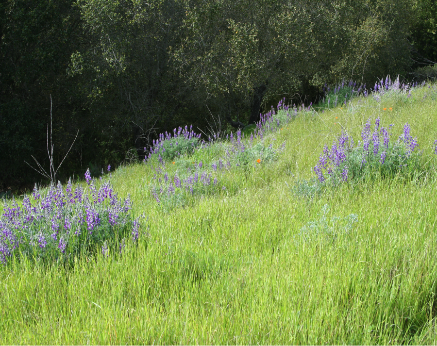
No other plant community speaks more poignantly of the California seasons than the grasslands – emerald green in the winter and early spring and tawny gold in the summer and fall. And in the undulating, rippling sea of grass you see the wind’s signature. Once, a quarter of the state was covered by grassland. But what I celebrate today is profoundly different from the grasslands before the arrival of the Europeans in the late 18th century.
The native perennial grasses have been mostly replaced by the imported European annuals, like the wild oats, whose seeds were often embedded in the fur of the long-horned cattle brought by the first Spaniards and Mexicans. The predominately native perennial grasses were not adapted to the heavy grazing pressure. As the native perennials declined the European annuals moved in. Grasslands, more than any other plant community, were affected by the arrival of the newcomers
The Bear Flag, the flag of the brief-lived republic before California became a state, shows the long-gone grizzly and the native perennial grasses which grew well spaced from one another. Spring wildflowers put on their annual display in these open spaces.
By the time William Brewer and the survey arrived in California the grasslands had been irrevocably altered.
Those interested in restoration have reintroduced bunch grasses in certain areas finding that redoing is slower business than the original undoing.
* * *
As a child, I reveled in grasslands. In the spring I rolled in the grass, staining my clothes green. I loved the pliant blades, and how green grasses held a trace of moisture even on dry days. I was soothed by the grassland simplicity, not yet understanding its complexity, seeing only an undifferentiated sea of blades. I liked that grasses accentuated the curve of the hills rather than hiding the contours under a coarser cover.
In the summer-dry grass, I would search for singing crickets, but they always stopped singing with my approach. The wind hissed in the dry stalks and picked up the seed-bearing fluff of dandelions carrying it off to new places. Dry grass, even though now lifeless, smelled sweet, like remembered barns full of hay.
Before dying back, grasses had cast out their seeds, which lay dormant, until the first rains in the fall coaxed open the hard seed liberating the first tiny blades of new grass. During the rainy months of winter, the lengthening grass spread over the hills like a green tide.


 “Seated in the trap, with our host holding the reins, we turned into a gorge… the road wound upward; the horses now splashing through the summer stream beneath gnarled and picturesque oaks, now out into the open, where the sun poured down through rifts in the cañon beneath a sky of tender blue, plunging into the narrow cañon again, where walls grew lofty and precipitous, shutting out the glare of sunlight; …”Three miles of this, and the charming canon road came to an abrupt end. The canon sides and the mountains suddenly melted away, and the horse dashed into a long, rolling valley, where the air was like velvet on the cheek and an incense of flowers and vines filled the nostrils.
 But last Sunday it was in the cab of battered green truck driven by one of Marla’s relatives. Several trucks of various vintages were waiting for passengers who had disembarked from the boat tied up at the end of the green trucks brought us up from the boat long pier. I carefully climbed up the ladder, aided by the crew, to the rough planks of the pier. I was more uncertain than usual because I had fallen on the deck of the boat when a sudden lurch had tossed me down on my back.


 The final ascent on stone steps to the base of the falls looked damp, making them especially perilous for my old legs. A bench at their base invited me to sit a while, let my granddaughter
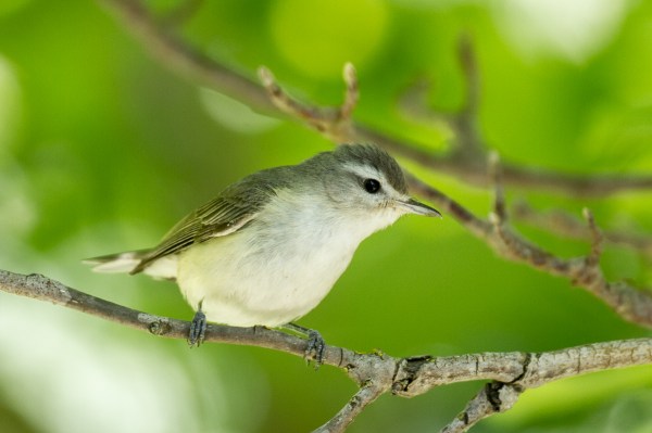
 Three weeks later with Berkeley birding friends, Bob Lewis and his wife, Hanno, we returned to Nojoqui Falls park to find the Purple Martins. Bob is sitting on the left. The heap on the right is actually me lying on my side watching martins in flight. Stretched out, has become my preferred position for watching birds of the sky and for general cloud-spotting.(I highly recommend to others who love clouds “The Cloudspotter’s Guide by Gavin Pretor-Pinney – the founder of The Cloud Appreciation Society)
 If you have lived a natural life say as a manzanita bush on the slope of the San Ynez Mountains you will understand the true meaning of summer. You will have grown new foliage or lengthened the leaves you have during late winter or early spring. You will have flowered and welcomed the bees. Now the flowers have turned into fruit, it’s time to let them ripen in the warm sun of the long days. It’s a season for repose or maybe deepening, as your tap root reaches down further to find water.
 canyon, but it’s when the sun is low in the sky before sunset that the mountains reveal their contours. Purple shadows fill the canyons while ridges and peaks glow in the late light. I learned by studying a map that the deep shadow in the saddle west of Montecito Peak is the top of Cold Spring Canyon.
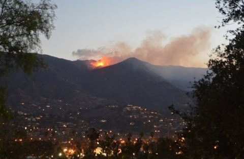

 and three large boulders across the dirt road. The trail – the dirt road – continues just beyond the level section when it becomes a narrow trail dropping steeply down to where Mission Creek begins. The Falls are a popular destination for hikers, most hiking up from Tunnel Trail off Tunnel Road. I’ve never hiked up far enough to reach the falls so I have to rely on the reports of others and the photos they took.


 arden, is often reduced to a few algae-filled pools.


 The slope was too steep to navigate on foot so I slid on my behind through what I would later discover was mostly poison oak. After an almost vertical slope of slippery clay, I found myself at the edge of a creek. And there was my bird, silent now, who fixed me with it’s round eye, made even rounder by a circle of white feathers. Late in the spring, the creek was reduced to a series of dark pools, laced together by threads of running water. Water striders skated across the surface while dragonflies darted about occasionally touching the water.


 decreasing coastal fogs when the Pacific High begins to slowly shift south allowing for the possibility of an early rain coming down from the north. Or when humidity sometimes moves north bringing the possibility of a thunderstorm and wonderful cloud effects. Exotic weather heightens one’s senses.
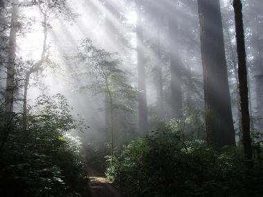 I’m also reading about how coastal fogs along the north coast have allowed the redwood forest to persist. Once, when the climate was much wetter, redwoods were common over much of the continent. But as the climate became drier and cooler, the redwood forests retreated to a narrow band along the immediate coast of Northern California visited by ocean fogs in the summer.
 ering the Great Central Valley can blot out the sun for days on end until the next rain storm sweeps the fog away for a time. The so-called radiation fog often follows the rain when the earth is both chilled and damp and the drier air above it condenses, forming fog. I remember once driving across the Sacramento Valley at night and I could see that the fog came up to the cow’s belly, leaving its head in the clear.
 up to a hundred gallons a day.
The newly-planted 700 tara trees will be able to eventually collect their own water. Tara trees produce valuable tannin.


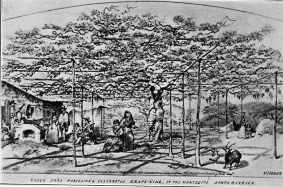 Once the sun came out again, several of the party rode to the hot springs five miles east and took a refreshing bath in the hot waters, on the way passing “the most remarkable grapevine I have ever seen.”
 The following year was desperately dry. On May 27, 1864 he writes:
 As a child, I reveled in grasslands. In the spring I rolled in the grass, staining my clothes green. I loved the pliant blades, and how green grasses held a trace of moisture even on dry days. I was soothed by the grassland simplicity, not yet understanding its complexity, seeing only an undifferentiated sea of blades. I liked that grasses accentuated the curve of the hills rather than hiding the contours under a coarser cover.